The way we perceive and understand our planet has transformed dramatically with the advent of advanced satellite mapping technologies. From the dense canopies of rainforests to the hidden depths of the ocean floor, these tools enable us to see beyond the surface, uncovering a world of intricate details and invaluable insights. Lidar, radar, and sonar are more than just technologies; they are windows into the Earth’s story, each contributing a unique perspective to the narrative of exploration and discovery. With almost real-time satellite view capabilities, we can now observe the planet’s dynamic changes as they happen, offering an unparalleled opportunity to understand and respond to the challenges of our rapidly evolving world.
3D rendered topographic grid wireframe. Gradient color island. Credit: freepik
Radar Technology
Radar technology, particularly Synthetic Aperture Radar (SAR), has revolutionized how we observe and interpret the Earth’s surface. Whereas optical imaging systems must rely on visible light and are often limited because of clouds, fog, or darkness, SAR operates in the microwave spectrum, enabling it to pierce atmospheric obstacles in high resolution. This makes it a necessity for obtaining live satellite images that give tantamount views independent of the weather or lighting conditions. Its aptitude for capturing high-resolution data whatever the conditions has made SAR a cornerstone for modern Earth observation.
At its core, SAR works by emitting microwave signals towards the Earth and analyzing the echoes that bounce back. These echoes carry detailed information about the surface they encounter, from the texture and structure of the ground to subtle changes in elevation. By synthesizing data collected from multiple angles as the satellite orbits, SAR creates detailed, three-dimensional representations of landscapes that optical sensors cannot achieve. This makes SAR an essential tool for producing current satellite imagery that reveals the Earth’s dynamic changes with exceptional accuracy.
Probably the most attractive aspect of the SAR technology is its flexibility-it can keep track of sprawling cities, deforestation in remote rainforests, and even subsidence in infrastructure at an accuracy of millimeters. In agriculture, SAR provides essential details related to soil moisture, health of crops, and planting patterns, which enable farmers to make decisions based on data for sustainable land management.
SAR is also a powerful ally in disaster response and mitigation. When natural catastrophes like floods, earthquakes, or landslides occur, SAR’s ability to penetrate cloud cover ensures that rescue and recovery teams receive accurate and timely information. This can be the difference between life and death in emergency scenarios. Moreover, its ability to detect changes in Earth’s surface over time, such as glacier movements or coastal erosion, plays a vital role in understanding and addressing climate change.
LiDAR Technology
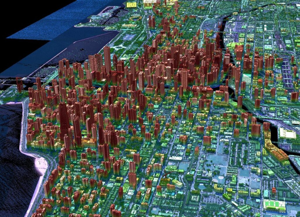
LiDAR technology, or Light Detection and Ranging, is a transformative tool in mapping the Earth’s surface with remarkable precision. It offers very detailed three-dimensional maps of landscapes by sending out laser pulses and calculating how long it takes them to bounce back. Unlike traditional imaging methods, it excels at going through heavy vegetation, bringing to light those features which would otherwise have remained hidden, like ruins of civilizations or minor changes in topography beneath dense forest covers. This complements the view of Earth from space for both natural and man-made features with unparalleled insight.

Geiger mode lidar over Chicago, IL. Credit: USGS
LiDAR operates by emitting thousands of laser pulses per second toward the ground and measuring the time it takes for them to return. Many pulses mean many data points, and with their combination comes a high-resolution topography map of the landscape. By integrating this data with up-to-date satellite images, researchers and planners can gain a deeper understanding of changes in land use, vegetation health, or even infrastructure conditions.
From urban planning to disaster recovery, LiDAR’s precision makes it invaluable. It can model flood-prone areas, monitor coastal erosion, and assist in forest management, ensuring sustainable development. Coupled with real-time satellite view technologies, LiDAR offers a dynamic way to track and analyze the Earth’s evolving landscapes with unmatched clarity and accuracy.
Sonar Technology
Sonar technology, or Sound Navigation and Ranging, is a groundbreaking method for exploring and mapping the underwater world. Unlike those technologies applied for surface imagery, sonar makes use of sound waves to penetrate deep into oceans, lakes, and rivers and unfold a concealed world beneath water.
Sonar works by sending out sound waves and analyzing their echoes as those waves bounce back from underwater features. The process generates detailed maps of the seafloor that detect everything from underwater mountains and shipwrecks to shifts in sediment layers. Combining sonar data with recent satellite images helps researchers connect what is happening beneath the water to surface events, such as coastal erosion or tectonic activity.
Sonar plays an important role in such areas as marine conservation and resource management. It assists in tracking marine species’ movements, identifying possible hazards to navigation, and studying underwater ecosystems with amazingly great precision. Together with the most relevant satellite images, sonar provides a more holistic view of the Earth’s complex and interconnected systems, bridging the gap between the surface and the deep.
 Petro Kogut has a PhD in Physics and Mathematics and is the author of multiple scientific publications. Among other topics, he has a specific focus on a satellite imagery processing and application in his academic research. Currently, Prof. Dr. Petro Kogut also works a science advisor.


