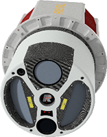
Avior Geospatial is enhancing its technological capabilities by adding a RIEGL VQ-1560 II-S airborne laser scanning system to their product portfolio. A leading provider of geospatial, mapping and surveying services, Avior leverages cutting-edge LiDAR and imaging technology to deliver high-quality, value-driven solutions with a focus on integrity, precision, and efficiency. The acquisition of this new RIEGL airborne system marks a significant addition to Avior Geospatial’s fleet, reinforcing the company’s commitment to providing top-tier geospatial services.
Left to right: Johannes Riegl, Jr. – President of RIEGL USA, Susan Licari – Vice President of RIEGL USA, Olga Kadatskiy – President of Avior Geospatial, Vladimir Kadatskiy – Vice President of Avior Geospatial, and Pavel Kryuchko – Data Analyst at Avior Geospatial.
Olga Kadatskiy, President of Avior Geospatial, stated, “With the new VQ-1560 II-S LiDAR sensor, we will significantly enhance our data collection and processing capabilities.”
 The RIEGL VQ-1560 II-S is a dual-channel hybrid laser and imaging system with unique “cross-fire” scan geometry for enhanced canopy penetration and vertical detail, equipped with a gyro-stabilized mount and a 150-megapixel camera for high-resolution imagery and high-density LiDAR data collection.
Michael Sitar, Division Manager of Airborne Laser Scanning at RIEGL USA stated, “Providing the RIEGL VQ-1560 II-S to Avior Geospatial will empower them to deliver even more precise and efficient geospatial solutions, enhancing their already impressive capabilities,”
Avior Geospatial, based in Central Florida, benefits from its close proximity to RIEGL USA, facilitating seamless collaboration and support. Avior Geospatial is dedicated to delivering the highest quality services, and this investment underscores its commitment to staying at the forefront of geospatial technology. The advanced sensor will be deployed in upcoming projects, continuing to offer exceptional service to clients.
About RIEGL
RIEGL is an international leading provider of cutting-edge technology in airborne, mobile, terrestrial, industrial and UAV-based laser scanning solutions for applications in surveying. RIEGL has been producing LiDAR systems commercially for over 40 years and focuses on pulsed time-of-flight laser radar technology in multiple wavelengths. RIEGL’s core smart-waveform technologies provide pure digital LiDAR signal processing, unique methodologies for resolving range ambiguities, multiple targets per laser shots, optimum distribution of measurements, calibrated amplitudes and reflectance estimates, as well as the seamless integration and calibration of systems. RIEGL’s Ultimate LiDARTM 3D scanners offer a wide array of performance characteristics and serve as a platform for continuing Innovation in 3D for the LiDAR industry. From the first inquiry, to purchase and integration of the system, as well as training and support, RIEGL maintains an outstanding history of reliability and support to their customers. Worldwide sales, training, support and services are delivered from RIEGL’s headquarters in Austria and in the USA; main offices in Japan, China, Hong Kong, Australia, Canada, UK, and Germany; and a worldwide network of representatives. www.rieglusa.com www.riegl.com
About Avior Geospatial
Avior Geospatial is a leading provider of geospatial, mapping, surveying, inspection, and consulting services. Using cutting-edge LiDAR and imaging technology, we deliver high-quality, value-driven solutions for our clients. Integrity and a strong commitment to excellence are at our core, supported by a proven team of industry experts with decades of experience. We specialize in power line mapping, shoreline and forest inventory mapping, as well as mining and transportation services, ensuring every project is completed with precision, efficiency, and integrity. aviorgeo.com


